
價格:免費
更新日期:2019-05-19
檔案大小:18M
目前版本:1.6.5
版本需求:Android 5.1 以上版本
官方網站:https://spatial.mapitgis.com
Email:feedback@mapitgis.com
聯絡地址:80 Walkerburn Drive Wishaw ML2 8RY United Kingdom

This application aim is to replicate our popular Mapit GIS data collector functionality with completely redesigned data management approach.
The app is designed to be simple and light, driven by new OGC file format for storing spatial data called geopackage.
The PDF user guide is available on our website - https://spatial.mapitgis.com/user-guide

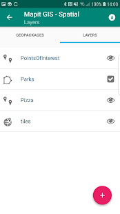
Directly from the app you can access existing multiple geopackages data sources and their content presented as tiled or feature layers.
You can also create new geopackage databases and feature layers and link their fields with the attribute set fields, so the data can be then collected using forms containing drop-down lists, multi-select list, barcode scanner etc. Please see our website for more details.
The collected data can be accessed immediately by simply copying the whole geopackage file to the PC and linking to it from GIS Software like qGIS.

The application is supporting multiple coordinates projections and you can specify your default coordinate system by providing the EPSG code in the settings - PRJ4 library is used to convert coordinates.
The application is capable to link with high precision GNSS systems - so you can get down to centimetre accuracy if required.
We are looking for constructive feedback and new ideas, so please email us if you feel the app can be improved in any way.

Mapit Spatial can be used in number of applications including:
- environmental surveys,
- woodland surveys,

- forestry planning and woodland management surveys,
- agriculture and soils' types surveys,
- road constructions,

- land surveying,
- solar panels applications,
- roofing and fencing,
- tree surveys,
- GPS and GNSS surveying,
- site surveying and soil samples gathering

- snow removal