
價格:免費
更新日期:2020-05-11
檔案大小:4.8 MB
目前版本:1.0.1
版本需求:系統需求:iOS 10.0 或以後版本。相容裝置:iPhone、iPad、iPod touch。
支援語言:英語

We integrate data from a variety of sources and provide a national view of fire events, fire hotspots, road closures, weather, and other critical bushfire information.
For fires, Bushfire.io now integrates information from a variety of feeds to show on one map:
- A national view of bushfire warnings and fire incidents.
- Detailed incident information (where available) for NSW, VIC, WA and ACT.
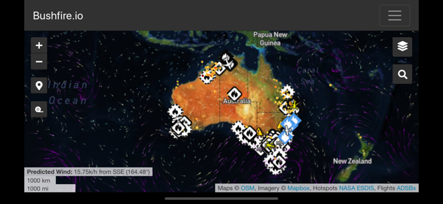
- Closed or hazardous roads for NSW, VIC and QLD.
- Recently burnt areas for VIC, QLD, and TAS.
- Bureau of Meteorology near-real-time weather observations.
- NOAA wind forecast (predicted wind) for the particle overlay.

- Major fire aircraft from ADSBx.
- Hotspots via NASA from NOAA-20, Suomi, Aqua and Terra.

支援平台:iPhone, iPad