
價格:免費
更新日期:2018-11-07
檔案大小:10.7 MB
目前版本:3.3.0
版本需求:需要 iOS 9.3 或以上版本。與 iPhone、iPad 及 iPod touch 相容。
支援語言:英語

Outside Maps is an iPhone/iPad/iPod Touch application that enables you to view and navigate a wide variety of mapping data using an easy-to-use touch interface.
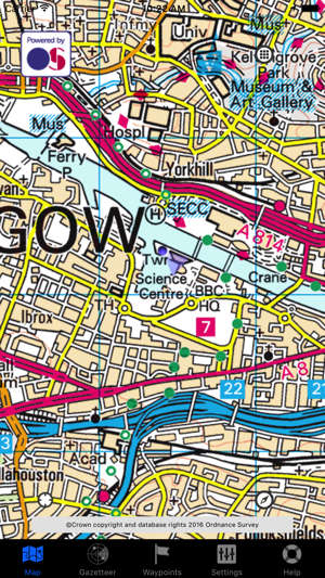
Outside Maps supports Ordnance Survey mapping for Great Britain at various scales including 1:50000.
Outside Maps supports WORLDWIDE coverage for OpenStreetMap, OpenCycleMap and the Stamen and Thunderforest map sources.
Outside Maps supports historic 1" Ordnance Survey mapping from 1880-1990 and 1921-1947 courtesy of the National Library of Scotland.
Outside Maps supports shaded terrain data for the UK only derived from Ordnance Survey OS Terrain 50.
Outside Maps includes ESRI aerial photography courtesy of ESRI.
Outside Maps includes the following features:
- Intuitive "slippy maps" interface
- Native iPad support in both portrait and landscape modes
- Current Ordnance Survey mapping including 1:50000 scale is available
- OpenStreetMap and derived data is supported at all available resolutions
- Historic 1" Ordnance Survey data from 1880-1990 and 1921-1947
- OpenCycleMap support
- Thunderforest "Landscape" and "Transport" mapping support
- Stamen mapping support
- ESRI aerial imagery
- Hill-shading mapping for the UK
- Full Ordnance Survey OSTN02 adjustments for highest accuracy (+/- 1m accuracy)
- Real-time position tracking via GPS (or WiFi-based positioning)
- Compass and bearing (either using GPS and movement tracking or hardware compass if available)
- "Lookahead" feature when moving at > 5mph
- Waypoints functionality including import and export via GPX format
- OS OpenSpace-driven postcode and placename lookup (online only)
- Grid reference and latitude/longitude lookup (offline)
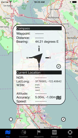
- what3words support (online only)
支援平台:iPhone, iPad