
價格:免費
更新日期:2020-05-31
檔案大小:8.6 MB
目前版本:2.4
版本需求:系統需求:iOS 8.1 或以後版本。相容裝置:iPhone、iPad、iPod touch。
敘述:Distance and Area Measure
從衛星視圖測量土地、道路、公園、國家、湖泊等。 計算距離、區域和周長。
此應用程式提供大多數競爭對手沒有的功能:
- 添加自訂的距離和麵積單位。
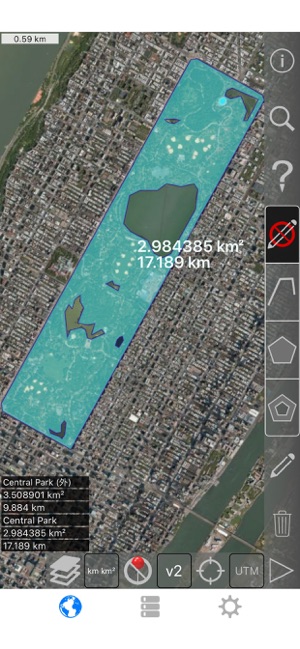
- 繪製室內多邊形。 例如,土地面積與水體中刪除。
- 將點添加到路徑的中間 (大部分只允許您將添加到路徑末尾) 自來水將添加到路徑的結尾。 長按要添加到中間的一條道路。
- 交換路徑或多邊形中的兩個點。
- 從 GPS 接收機添加您當前的位置。
特點:
- 3 的地圖圖層選項
- 匯出和導入.kml 檔通過 Dropbox、 iCloud、 電子郵件等
- 引腳可拖動並手動編輯
- 名稱,注意到,並顏色每個路徑和多邊形的欄位
- 通過電子郵件或文本消息路徑和多邊形資料
- 4 詳細模式。 僅查看要查看的資訊
- 按郵遞區號、 城市、 位址等搜索
- 在地圖上的點附近獲取位址
4 種繪圖模式:
- 路徑
- 多邊形
- 與空心空格內多邊形
- 沒有編輯模式 (以防止意外編輯)
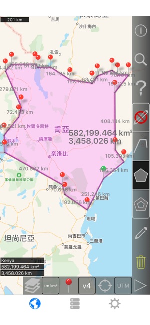
顯示路徑的值:
- 總距離
- 每個航點的增量距離
對於多邊形顯示的值:
- 地區
- 週邊
- 為每個邊的的距離
將點添加到路徑或多邊形中的四種方法 1:
- 點擊地圖
- 使用您當前的位置
- 手動輸入座標
- 導入.kml 檔
預設距離單位包括:
- 米
- 英尺
- 碼
- 公里
- 英里
- 航海裡程
預設地區單位包括:
- 平方公尺
- 平方尺
- 平方碼
- 平方千米
- 平方英哩
- 平方海裡
- 平方英畝
- 平方公頃
座標格式:
- 度
- 度,分鐘
- 度,分鐘秒
- UTM / UPS (通用橫向墨卡托) / (通用極性立體)
- MGRS(軍用電網參考系統)

English:
Measure land, roads, parks, countries, lakes, etc from a satellite view. Calculates distances, areas, and perimeters.
Features that this application offers that most competitors do not:
- Add custom distance and area units.
- Draw interior polygons. For example, land area with bodies of water removed.
- Add a point to the middle of a path (Most only allow you to add to the end of the path) Tap to add to the end of a path. Long press to add to the middle of a path.
- Swap two points in a path or polygon.
- Add your current location from GPS receiver.
Features:
- 3 map layer options
- Export and import .kml files via Dropbox, iCloud, email, etc
- Pins are draggable and manually editable
- Name, notes, and color fields for each path and polygon
- Email or text message path and polygon data
- 4 verbosity modes. See only the information that you want to see
- Search by postal code, city, address, etc
- Get addresses near point on map
4 drawing modes:
- Path
- Polygon
- Polygon with hollow spaces inside
- No edit mode (to prevent accidental edits)
Values displayed for paths:
- Total distance
- Incremental distance for each waypoint
Values displayed for polygons:
- Area
- Perimeter
- Distance for each side
Add points to a path or polygon in 1 of 4 ways:
- Tap on the map
- Use current location
- Enter coordinates manually
- Import .kml file
Default distance units include:
- Meter
- Foot
- Yard
- Kilometer
- Mile
- Nautical mile
Default area units include:
- Square meter
- Square foot
- Square yard
- Square kilometer
- Square mile
- Square nautical mile
- Square acre
- Square hectare
Coordinate formats:
- Degrees
- Degrees, minutes
- Degrees, minutes, seconds
- UTM / UPS (Universal Transverse Mercator) / (Universal Polar Stereographic)
- MGRS (Military Grid Reference System)

支援平台:iPhone, iPad