
價格:免費
更新日期:2018-03-09
檔案大小:5.9 MB
目前版本:2.2
版本需求:需要 iOS 8.1 或以上版本。與 iPhone、iPad 及 iPod touch 相容。
支援語言:英語
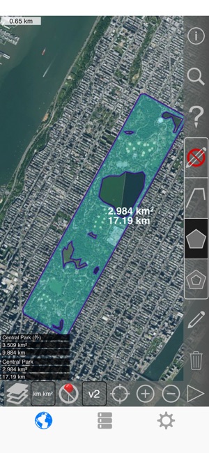
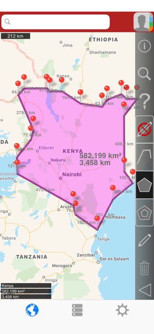
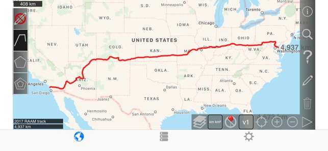
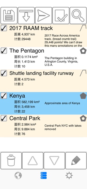
測量建築物、 道路、 公園、 土地、 國家、 湖泊、 從衛星視圖等。 計算距離、 周長和麵積。
此應用程式提供大多數競爭對手沒有的功能:
- 添加自訂的距離和麵積單位。
- 繪製室內多邊形 (如圖示)
- 繪製室內多邊形。 例如,土地面積與水體中刪除。
- 將點添加到路徑的中間 (大部分只允許您將添加到路徑末尾) 自來水將添加到路徑的結尾。 長按要添加到中間的一條道路。
- 交換路徑或多邊形中的兩個點。
- 從 GPS 接收機添加您當前的位置。
特點:
- 3 的地圖圖層選項
- 匯出和導入.kml 檔通過 Dropbox、 iCloud、 電子郵件等
- 針腳可拖動
- 名稱,注意到,並顏色每個路徑和多邊形的欄位
- 通過電子郵件或文本消息路徑和多邊形資料
- 4 詳細模式。 僅查看要查看的資訊
- 按郵遞區號、 城市、 位址等搜索
- 在地圖上的點附近獲取位址
4 種繪圖模式:
- 路徑
- 多邊形
- 與空心空格內多邊形
- 沒有編輯模式 (以防止意外編輯)
顯示路徑的值:
- 總距離
- 每個航點的增量距離
對於多邊形顯示的值:
- 地區
- 週邊
- 為每個邊的的距離
將點添加到路徑或多邊形中的四種方法 1:
- 點擊地圖
- 使用您當前的位置
- 手動輸入座標
- 導入.kml 檔
預設距離單位包括:
- 米
- 英尺
- 碼
- 公里
- 英里
- 航海裡程
預設地區單位包括:
- 米²
- 英尺²
- 圍場²
- 公里²
- 公里²
- 航海公里²
- 英畝²
- 公頃²
請注意, 此應用程式使用的是蘋果地圖。我們不能改變衛星圖像。如果您注意到圖像已不在焦點或過時, 請在驗證該問題也存在於蘋果的地圖應用程式中後, 向 apple 報告。
有關詳細資訊, 請訪問支援頁面。
English:
Measure buildings, roads, parks, land, countries, lakes, etc from a satellite view. Calculates distances, areas, and perimeters.
Features that this application offers that most competitors do not:
- Add custom distance and area units.
- Draw interior polygons (like the icon)
- Draw interior polygons. For example, land area with bodies of water removed.
- Add a point to the middle of a path (Most only allow you to add to the end of the path) Tap to add to the end of a path. Long press to add to the middle of a path.
- Swap two points in a path or polygon.
- Add your current location from GPS receiver.
Features:
- 3 map layer options
- Export and import .kml files via Dropbox, iCloud, email, etc
- Pins are draggable
- Name, notes, and color fields for each path and polygon
- Email or text message path and polygon data
- 4 verbosity modes. See only the information that you want to see
- Search by postal code, city, address, etc
- Get addresses near point on map
4 drawing modes:
- Path
- Polygon
- Polygon with hollow spaces inside
- No edit mode (to prevent accidental edits)
Values displayed for paths:
- Total distance
- Incremental distance for each waypoint
Values displayed for polygons:
- Area
- Perimeter
- Distance for each side
Add points to a path or polygon in 1 of 4 ways:
- Tap on the map
- Use current location
- Enter coordinates manually
- Import .kml file
Default distance units include:
- Meter
- Foot
- Yard
- Kilometer
- Mile
- Nautical mile
Default area units include:
- Meter ²
- Foot ²
- Yard ²
- Kilometer ²
- Mile ²
- Nautical mile ²
- Acre ²
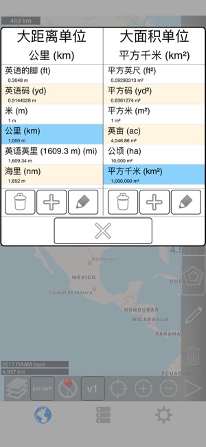
- Hectare ²
Note that this application uses Apple Maps. We cannot change the satellite images. If you notice that the imagery is out of focus or out of date, please report this to Apple after verifying that the issue also exists in the Maps app from Apple.
Please visit the support page for more details.
支援平台:iPhone, iPad