
價格:免費
更新日期:2019-05-05
檔案大小:80.6 MB
目前版本:1.34.2
版本需求:需要 iOS 9.0 或以上版本。與 iPhone、iPad 及 iPod touch 相容。
支援語言:法文, 英語
Bring the mountains with you wherever you go!
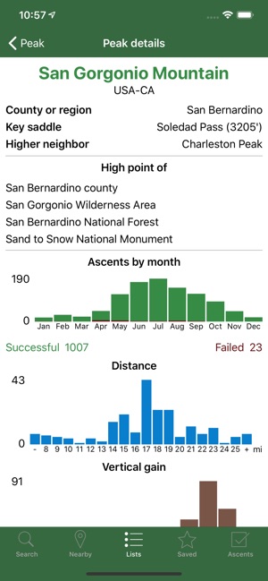
* Search the huge database of mountains and trip reports from Peakbagger.com and ListsOfJohn.com
* Keep track of your climbs, even when offline
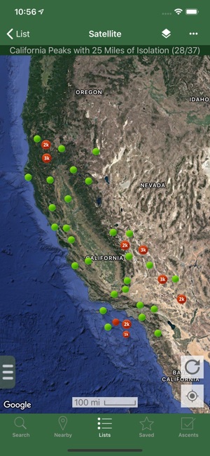
* Measure your progress against hundreds of peak lists
* Get route information and directions from SummitPost and ListsofJohn.com
* Find peaks near your current location, or near other peaks
* Filter peaks by prominence, or climbed vs. unclimbed, or inclusion on a peak list
* See what other peaks are often climbed together with your target peak
* Create custom peak lists and order them by your personal priorities
* See weather forecasts for all U.S. peaks from the National Weather Service, and for 11,000+ major peaks worldwide from mountain-forecast.com
* See topographic maps for anywhere in the world (+/- 60 degrees latitude)
* See protected land area coverage in North America, Europe, Japan, and Australia and New Zealand
* US Forest Service maps
* Save a peak to your device for offline use, including topographic maps
* Download topographic maps along a route for offline use
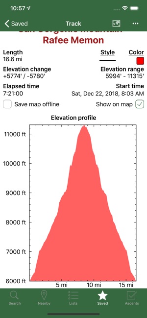
* Import and display GPS tracks and waypoints instantly
* On-screen compass keeps you oriented along your track
* Long click on the map to get Street View, elevation, and driving directions
* Record your starting elevation, distance, and information about the gear and route you used
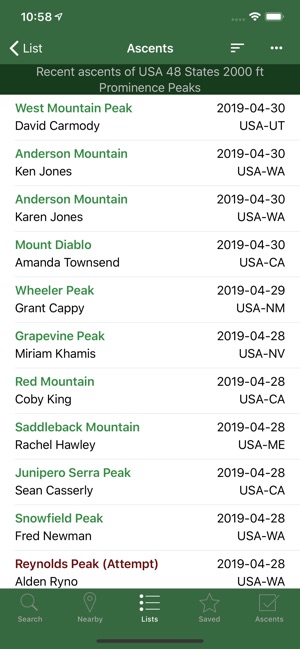
* Leaderboards show the top climbers for each peak list
* See peaks your Peakbagger buddies have climbed recently
* Update your buddy list from right in the app
* Automatically upload your ascents to ListsOfJohn (U.S. peaks)
* Show daily satellite imagery for any location on any day since 2011
* Display elevation profile for a GPS track, and show your current location along the profile
* See sunrise and sunset times at a peak, even when offline
* Daily forest fire coverage, and historical coverage for the last 5 years (U.S.)
* Constantly updated weather radar and smoke layers on the map
* Record GPS tracks, including timestamps, and add them to your ascents
* Record waypoints along your route
* Organize your tracks in folders
* Automatically find survey benchmarks near peaks (U.S.)
* Hunt benchmarks and get your finds recorded in the official government benchmark data sheets
HOW TO IMPORT GPS TRACKS - 2 OPTIONS
1) Click on the "Load GPS track" link on the ascent details page for an ascent that has a GPS track.
2) Click on a GPX, KML or KMZ file on your phone, for example, in an email attachment or on Google Drive
Continued use of GPS running in the background can dramatically decrease battery life.
支援平台:iPhone, iPad