
價格:免費
更新日期:2017-10-18
檔案大小:12.1 MB
目前版本:1.0.4
版本需求:需要 iOS 8.0 或以上版本。與 iPhone、iPad 及 iPod touch 相容。
支援語言:英語
ESPAÑOL
Bizkaiako Bidegorriak te permite obtener información sobre las vías ciclistas y bidegorris del Territorio Histórico de Bizkaia.
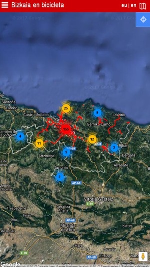
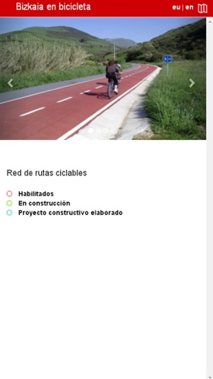
Sobre un soporte del mapa de Bizkaia se pueden consultar los tramos ya ejecutados, así como los que se encuentran en construcción y los que están proyectados.
Complementando la información existente de la red, se muestra ubicaciones de interés como pueden ser: bicicleta pública, sistema de intermodalidad con el transporte público, museos, puntos de interés natural y paisajista, puntos de interés cultural, playas, áreas recreativas y de descanso, así como puntos de información y turismo.
Por cada una de ellas es posible ver el itinerario propuesto sobre el mapa así como la siguiente información de la ruta:
- Descripción breve de la ruta.
- Un folleto en formato PDF que describe en detalle la ruta.
- Perfil de itinerario.
- Vídeo del recorrido.
- Posibilidad de descarga del itinerario en formato GPX.
Es posible consultar los folletos y los vídeos sin tener que seleccionar una ruta determinada, ya que se ofrece una lista de cada tipo.
Haciendo uso del menú de la aplicación, se puede cambiar en el tipo de mapa base, así como activar o no las diferentes ubicaciones de interés ya descritas.
Existe la posibilidad de seleccionar un origen y un destino y haciendo uso de los servicios de Google Maps, se muestra el recorrido en bicicleta que existe entre ellos.
EUSKERA
Bizkaiko Bidegorriak aplikazioari esker Bizkaiko Lurralde Historikoko bizikleta-bideei eta bidegorriei buruzko informazioa eduki ahal izango duzu.
Bizkaiko maparen euskarri batean eginda dauden zatiak ikus daitezke, baita eraikitzen ari direnak eta eraikiko direnak ere.
Sarean dagoen informazioaren osagarri gisa toki interesgarriak adierazita daude. Esaterako: bizikleta publikoa, sistema intermodala (garraio publikoarekin), museoak, natura edo paisai aldetik interesgarriak diren puntuak, kultura-intereseko puntuak, hondartzak, aisialdi eta atseden guneak, informazio eta turismo puntuak.
Ibilbide bakoitzarentzako proposatutako bidea ikus daiteke mapan, baita ibilbideari buruzko honako informazio hau ere:
- Bidearen deskribapen laburra.
- Bidea deskribatzen duen PDF formatuko liburuxka. Bidearen profilaIbilbidearen bideoa.Ibilbidea GPX formatuan deskargatzeko aukera.
Ibilbide zehatz bat aukeratu gabe liburuxkak eta bideoak kontsultatzeko aukera d**o. Izan ere, mota bakoitzeko zerrenda bat eskaintzen da.
Aplikazioaren menua erabilita oinarrizko mapa mota alda daiteke, eta deskribatutako intereseko kokapenak aktibatzeko aukera d**o.
Jatorria eta helburua aukera daitezke, eta Google Mapsen zerbitzuak erabiliz bizikleta-ibilbidea ikusgai d**o.
ENGLISH
Bizkaiako Bidegorriak provides information on the cycling routes and bidegorris or bike lanes in Bizkaia.
The map of Bizkaia shows the sections already implemented, those under construction and those in the pipeline.
In addition to the existing information on the network, it shows locations of interest, including: public cycle scheme, intermodality system with public transport, museums, points of landscape and natural interest, points of cultural interest, beaches, rest and recreational areas, along with information and tourism points.
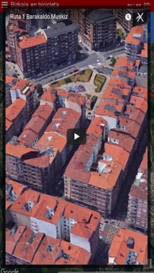
The proposed itinerary for each of them is shown on the map, along with the following information on the route:
- Brief description of the route.
- A leaflet in PDF format that describe the route in detail.
- Itinerary profile.
- Video of the route.
- Possibility to download the itinerary in GPX format.
The leaflets and videos can be seen without having to select a specific route, as a list of each type is available.
Using the app's menu, you can change the basic map type and decided whether or not to activate the different locations of interest described above.
There is the possibility of selecting a starting point and a destination, and the cycle route between them is shown using the Google Maps services.
支援平台:iPhone, iPad