
價格:免費
更新日期:2018-03-28
檔案大小:159.8 MB
目前版本:1.0.2
版本需求:需要 iOS 8.0 或以上版本。與 iPhone、iPad 及 iPod touch 相容。
支援語言:俄文, 德語, 日語, 法文, 瑞典文, 簡體中文, 繁體中文, 義大利文, 英語, 荷蘭文, 葡萄牙文, 西班牙文
Plan, navigate and share your next 4x4 or overland adventure through the United States and Canada with the Hema Explorer overland navigation app for North America:
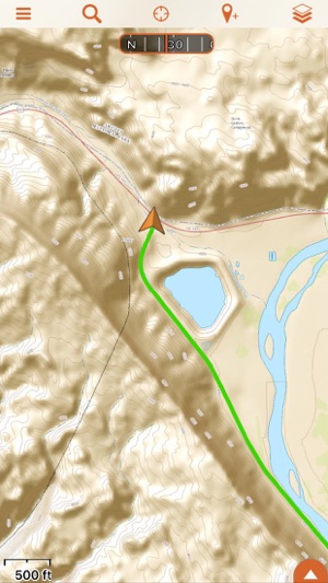
• Track your GPS position in real-time on offline maps
• Use trusted topographic mapping to explore North America backcountry: USGS Topo, Thunderforest Outdoors and Canada Topo
• Use additional street and touring maps for navigating populated areas: Hema USA Road Map, HERE Street and Canada Street mapping

• Generate an offline route to an address or waypoint using Quick Routing
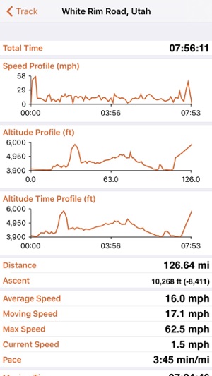
• Save a log of your trip with track recordings, geotagged photos, waypoints and trip notes
• Backup all your trip data to your free Hema Explorer Cloud account which you can share with the Hema Explorer community
• Share your trips online with friends and family

PLAN
Generate a route line to an address or waypoint using Quick Routing, manually create point-to-point routes, or mark important locations using waypoints to plan your journey in full. You can even organise your data for each specific trip by saving it to an individual folder, allowing you to keep all your downloaded maps, waypoints and routes in one place.
NAVIGATE
By delivering offline mapping to your mobile device, Hema Explorer makes it easy to navigate 4x4 and overland adventures throughout North America. Download the maps you need offline before you go, then track your position as you travel and save a log of your journey to find your way home. With Hema Explorer, you get full access to detailed USGS Topographic and USGS 7.5 mapping, the Hema USA Road Map, Thunderforest Outdoors, Canada Topo and Canada Street, in addition to HERE Street, Terrain and Aerial imagery mapping for North America.
SHARE
Hema Explorer lets you record your journey with track logs, geotagged photos, waypoints and trip notes, which you can automatically backup to your free Hema Explorer Cloud account. You can then post your trips to the Hema Explorer Cloud trip gallery, where you can share your adventures with the Hema Explorer community, browse and comment on other people’s trails, or post your trip directly to Facebook and Twitter.
Note: Continued use of GPS running in the background can dramatically decrease battery life.

支援平台:iPhone, iPad