
價格:免費
更新日期:2019-06-08
檔案大小:221k
目前版本:2.3.1
版本需求:Android 2.2 以上版本
官方網站:mailto:innovative.app.designs@gmail.com

This program allows you to view and record GPS points, pipelines, tracks, distances, and areas while in the field. The device’s built in altimeter, when equipped, provides precise elevation data. Tracks can be viewed in Profile and Plan View with recent aerial imagery in the background. The tracks are displayed with color gradation based on the user’s preference of displaying speed, elevation, or grade. The data is easily saved and sent to email with the push of a button on email capable devices.

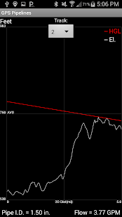
The water pipeline feature allows the user to assign a pipe diameter, Hazen-William’s Roughness Coefficient, flow direction, and inlet/outlet pressure to calculate a pipe’s maximum flow along tracks. The flow calculation is calculated continuously and assumes full pipe flow (Continuous acting air vents are typically installed at summits to release air and prevent debris from being pulled into pipeline leaks). The real time profile view, called water pipe chart, includes the hydraulic grade line so users can visualize the water pressure in the pipe and identify pipe summits that will reduce pipe flow.

The data is saved with the date, time, inputs, pipe flow, latitude, longitude, speed, elevation, % grade, 2D distance, 3D distance, hydraulic grade line, track description, track number, and waypoint information. Saved data can be reloaded into the program or imported into other programs.
For GIS (Geographic Information System) users, note that latitude and longitude information is WGS 84 (World Geodetic System 1984) when importing.

The data files can be saved as .csv (comma separated values), GPX, and TCX for easy import into GIS (Geographic Information System), GPS (Global Position System), and Civil Engineering applications.
Enjoy!