
價格:免費
更新日期:2019-06-25
檔案大小:180.5 MB
目前版本:14.0
版本需求:需要 iOS 9.0 或以上版本。與 iPhone、iPad 及 iPod touch 相容。
支援語言:德語, 法文, 義大利文, 英語, 西班牙文

Nautical charts for cruising, fishing, sailing, diving and all your activities on the water. Get the same detailed marine and lake charts and advanced features as on the best GPS plotters.
> TRY FOR FREE: Download and get a trial for all our charts and features.
> SUBSCRIBE FOR 1 YEAR: Choose your favorite areas and subscribe. Tap Menu > Me > Subscription. Chart layers will reside on your device even after expiration.
Plan routes for your next coastal cruising adventure, and improve your depth awareness to find the best fishing spots with our contour maps. You can sail with confidence knowing you have a variety of helpful features at your fingertips.
THE SUBSCRIPTION INCLUDES:
> CHART LAYERS FOR OFFLINE USE
- NAUTICAL CHART: This accurate and thorough map of lakes and marine areas is continuously expanded with data from several highly qualified public and private sources.
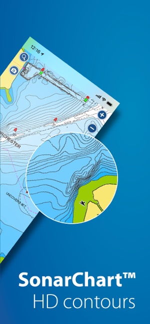
- SONARCHART™: This 1’ (0.5 m) HD bathymetry map with extraordinary bottom contour detail is enhanced by millions of sonar logs contributed by boaters such as you.
- COMMUNITY EDITS and ACTIVECAPTAIN® COMMUNITY: Join a bigger crowd! Get more local information from the Navionics and the Garmin ActiveCaptain boating community.
- U.S. GOVERNMENT CHARTS (NOAA): These charts are available with the following coverage areas: USA, U.S. and Canada, Mexico, Caribbean to Brazil, Pacific Islands, Asia and Africa.
> DAILY CHART UPDATES: The most current charts with more than 2,000 updates made every day.
> FEATURES
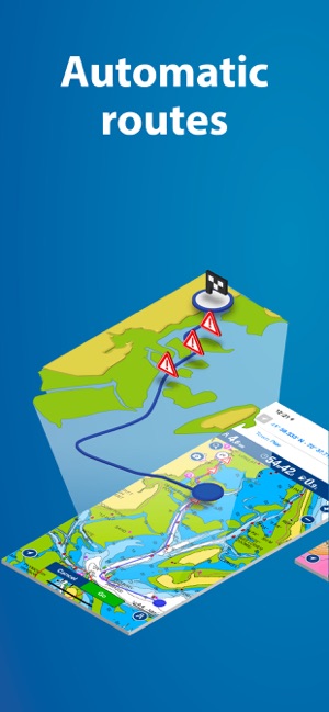
- DOCK-TO-DOCK AUTOROUTING*: Creates a suggested route, from a real starting point to a real ending point, based on chart data and navigation aids. It provides advanced route planning with ETA, distance to arrival, heading to waypoint, fuel consumption and more.
- ADVANCED MAP OPTIONS: Customize chart views to change overlay, highlight shallow areas, target multiple fishing ranges and more.
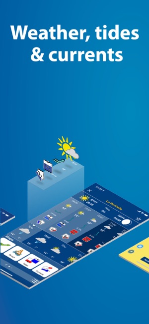
- WEATHER AND TIDES: Access real-time weather data along with daily and hourly forecasts, and get wind, weather buoys, tides and currents overlaid on your map.
- GPX IMPORT/EXPORT: Easily handle your tracks, routes and markers. Share, store and display them on different apps, plotters and other devices.
- PLOTTER SYNC: Owners of compatible plotters can transfer routes and markers, update charts and more.
- TIMELINE: Enjoy looking back at your trips in the track timeline.

RENEW SUBSCRIPTION
After 1 year, you can renew your subscription or keep using your maps with free features.
FREE FEATURES
- SONARCHART™ LIVE: Create your own 1’ (0.5 m) HD bathymetry maps that display in real time while navigating. Connect the Boating app wirelessly to a compatible sonar/plotter. You can also automatically share your sonar logs, which helps us improve charts.
- Includes track, route, distance, markers, wind forecasts, map options, sync my data, share location and more.
NOTES:
- Use this app on iPhone® and iPad® devices. Sync charts and data: Go to Menu > Me > Subscription, and restore your purchases.
- Updates are available with iOS 9.0 or higher. An iPad device with Wi-Fi® connectivity locates your approximate position if it is connected to Wi-Fi. An iPad Wi-Fi + 3G model operates similarly to an iPhone device with regard to GPS.
*Autorouting is for planning purposes only and does not replace safe navigation operations.

支援平台:iPhone, iPad