價格:免費
更新日期:2017-03-16
檔案大小:104.7 MB
目前版本:3.5
版本需求:需要 iOS 9.0 或以上版本。與 iPhone、iPad 及 iPod touch 相容。
支援語言:英語

Complete new flying and shooting dimension for DJI drones with innovative features.
• Compatible DJI platform: Mavic Pro, Phantom 3/4, Inspire 1/2, Matrice 100/600
• Compatible DJI camera: Zenmuse X3, X5, X5R, Z3, Z30, X4S, X5S
• Compatible iOS devices: iPad Air/Air 2/Pro, iPad mini 2/3/4, iPhone 5s/6/6+/6s/6s+/7/7+/SE
• Both app and support are in English only
--Camera--
• Navigation Map consists of accurate Google Map and Pilot Wand
• Up-to 12 custom telemetry data with either vertical or horizontal layout
• Unique and creative "Touchless UI" allows pilots to change camera settings and control the app without touching screen
• Real-time battery consumption meter - mAh/km or mAh/mi
• Custom Warning message
• Screen Recorder

--Mission Planner --
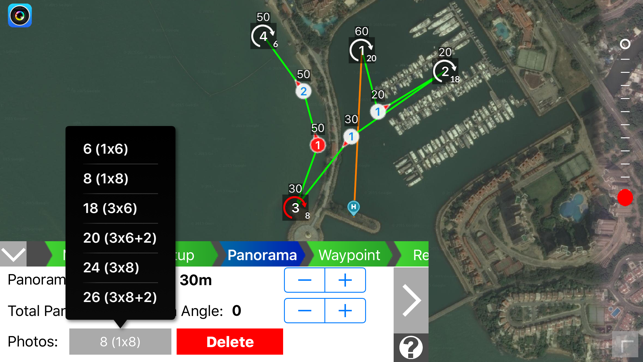
Mission Planner is an intelligent ground station with unique TERRAIN ELEVATION to program & save autonomous WAYPOINT, ORBIT and PANORAMA flights for superior footage. With aid of powerful auto-focus gimbal control, it always keeps your targets right at the center of your footage.
• Waypoint, Target-Waypoint (multi-POI), Pano-Waypoint (multi-panorama), Panorama (video & photo modes), Orbit
• Built-in terrain elevation from multiple DEM data sources
• Pre-plan mission offline without requiring connection to RC or aircraft
• Mission continuous even RC signal lost
• Guide you through mission setup by simple step-by-step procedures
• Define up-to 99 waypoints in a single mission
• Custom and standard configuration in Panorama & Pano-WP
• Auto-Tilt gimbal control
• Preliminary flight estimation (longest WP, travel distance, time & battery)
• Synchronize missions to iCloud as backup and update across multiple devices automatically.

• Direct copy email attached mission files to Mission Planner
--FPV Goggles--
FPV Goggles provides complete innovative features that every FPV enthusiast will enjoy flying. It turns your iPhone to FPV Goggles with immersive head tracking camera auto-tilt control. The app converts live video feed to side-by-side format in conjunction with Navigation Map for flying with VR headset.
• Creative and unique "Touchless UI" allows pilots to control the app without touching screen. There is almost impossible to touch iPhone screen when it's sitting inside the headset.
• Immersive and flexible Head Tracking controls camera tilt based on your head movement.
• Redesign UI to fit better of side-by-side goggles screen layout, such as Navigation Map and Custom Telemetry.
• Flexible adjustment for different size iPhone, headset and pilots' eyes
• FPV Goggles provides Navigation Map, full telemetry, warning messages and camera settings in the app.
• Toggle iPhone camera (to view surrounding) and live video feed in FPV Goggles mode
--3D Model--
• New 3D MODEL turns DJI drone to aerial 3D scanner to scan basically anything (like a house, building or any landmark) from the sky for generating 3D model
• 3D MODEL includes planning mission offline, terrain elevation, Auto-Tilt gimbal control, preliminary flight estimation, iCloud Sync 3D model project

--Flight Log--
Flight Log offers innovative custom telemetry and other statistics data. It allows pilots to review their flight records and playback flight path with custom telemetry data right after landing on your iDevice without internet connection. You can delete, import and export flights logs to CSV file for third-party application (such as DashWare) for further manipulation.

支援平台:iPhone, iPad
