價格:免費
更新日期:2016-11-21
檔案大小:5.9 MB
目前版本:3.0
版本需求:需要 iOS 8.1 或以上版本。與 iPhone、iPad 2 Wi‑Fi + 行動網路、iPad(第三代)Wi-Fi + 行動網路、iPad(第四代)Wi-Fi + 行動網路、iPad mini Wi-Fi + Cellular、iPad Air Wi-Fi + Cellular、iPad mini 2 Wi-Fi + Cellular、iPad Air 2 Wi-Fi + Cellular、iPad mini 3 Wi-Fi + Cellular、iPad mini 4 Wi-Fi + Cellular、12.9 吋 iPad Pro Wi-Fi + Cellular、iPad Pro(9.7 吋)Wi-Fi + 行動網路、iPad(第五代)Wi-Fi + 行動網路、iPad Pro(12.9 吋)(第二代)Wi-Fi + 行動網路、iPad Pro(10.5 吋)Wi-Fi + 行動網路、iPad Wi-Fi + Cellular(第六代)、iPad Pro(11 吋) Wi-Fi + 行動網路、iPad Pro(12.9 吋)Wi-Fi + 行動網路、iPad mini(第 5 代)Wi-Fi + 行動網路 及 iPad Air(第 3 代)Wi-Fi + 行動網路 相容。
支援語言:英語

StepTRAX is the ultimate fitness companion for every walking enthusiast. It is a precision pedometer and tracking app and works equally well whether you are running, jogging or walking.
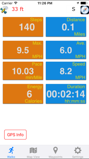
Traditional pedometers depend on motion detection for step counts and are not very reliable. StepTRAX uses a unique solution to accurately calculate the number steps taken. Since the app can accurately determine the distance traveled, based on the stride length, it can very accurately calculate the number of steps.
StepTRAX is a versatile app that can also be used a pedometer or a speedometer. It can track your position and path in real-time. Trip points are displayed on road or satellite/hybrid maps using push pins and polyline segments.
FEATURES:
Stunning User Interface (UI) with large fonts
Intuitive, simple and easy to use with many advanced features and functions.
Measurements, Mapping and marking Trip points.

Intuitive, simple and easy to use with many advanced features and functions.
Unique noise rejection algorithm for accurate distance and speed measurements at walking speeds.
Accurately monitor several essential parameters with very high accuracy.
No calibration required.
Background mode - all phone functions are available while the App runs in the background.
The App works anywhere outdoors, including areas with no cell coverage. Only requirement is GPS coverage.
MAPPING FEATURES
With data coverage, view and track your current location in real-time on the Map view

Map has both street view and satellite view
Mark you position and tracks with push pins and polyline segments
TRIP /WAYPOINT FEATURES
Automatically or manually track and mark your Trip/WayPoints. This feature is useful if you need to mark specific locations on your trip. Trip points can be viewed, but cannot saved and exported.
FUNCTIONS: StepTRAX supports 10+ functions: Measurements: Steps, distance, average speed, max speed, pace, speed, calories, elapsed time, latitude, longitude, altitude, elevation gain, grade, satellite accuracy, direction/heading.
Units: Metric (KM, KMPH, Meters, meters/sec.) and English (Miles, MPH, feet, feet/sec.)
Persist user settings, odometer and elapsed timer. Change measurement units on the fly.
Note:

Continued use of GPS running in the background can dramatically decrease battery life.
Data connection is required to see map.
GPS is not always accurate due to hardware sensor limitations.

支援平台:iPhone, iPad
