
價格:免費
更新日期:2019-04-19
檔案大小:7.6M
目前版本:3.23
版本需求:Android 2.2 以上版本
官方網站:http://www.qrouting.com
Email:qrouting@gmail.com
聯絡地址:Aravaca 3D 28040 Madrid

QRouting is a complete Flight Planning Software for Aviation.
Designed by pilots for pilots.
Important: If the app doesn’t work in your phone or tablet, please, try our freeware version in our web qrouting.com

- Weight and Balance
Calculates weight and balance based on the POH. Displays results on a graph. More than 20 popular planes in our database. You can also add more or send us a request to add yours.

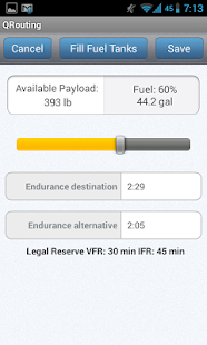
- Fuel management
Fuel calculations are very precise. They are based on the performance charts of your POH, with the fuel flows during climb, cruise and descent corrected for altitude, pressure, temperature and wind. The app tells you the maximum fuel you can take not to exceed the Maximum Take Off Weight. It also calculates if that fuel is enough for you route to the destination and to the alternative.
- Operational Flight Plan
We obtain the true heading, the magnetic heading and the distance for each leg of the flight plan, corrected for wind, pressure and temperature. The drift is calculated. If we change the aircraft, the flight plan is recalculated automatically to the new performance. Performance charts for several general aviation planes are already loaded. The waypoint database includes more than 120.000 points worldwide. It also includes the coordinates for 18.000 Spanish villages and towns. Practically all airports, including ULM
- Flying the route with moving map with aeronautical charts

The Flight Plan is plotted in Oruxmaps (www.oruxmaps.com) and using the phone's GPS we see the route in a moving map. You can scan the chart you carry on board and use it as a moving map. VFR and IFR charts for the US are available on line. Oruxmaps allows you to download them and use them off-line in the aircraft.
You can make a GOTO to any waypoint of the database. Also the app shows you the nearest airport, so you can make a GOTO to any of them if needed.
- Downloads Aviation Weather Information Metar and Taf,

It automatically selects the Weather Stations more convenient to your route from the Weather Database already included. It fetches for you the last report.
- Downloads Aviation NOTAM
The app automatically selects the NOTAM need for your route and downloads it.

To report errors, make any enhancement suggestion or get quick and friendly support, please mail to qrouting@gmail.com
Visit www.qrouting.com
Internet Permission added to download Notam

Location Permission added to fetch GPS position